MYSTERY SOLVERS VII A Community is facing the problem Giving passage to Ambulance in emergencies.
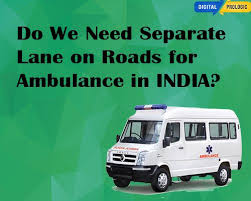
Community is facing the problem Giving passage to Ambulance in emergencies. Seperate lane for ambulance
Awarpur, Chandrapur Maharashtra
Solution
| Component | Description |
|---|---|
| Technical Components | ### **Comprehensive Analysis: Emergency Lane Ambulance Solution** #### **1. Technical Components Needed** | **Category** | **Components** | **Purpose** | |----------------------------|-------------------------------------------------------------------------------|-------------| | **Infrastructure** | Dedicated lanes (red/blue pavement, reflective signs), smart traffic lights, median gaps | Ensure clear ambulance passage | | **Sensors & Tracking** | GPS transponders (ambulances), RFID tags, IoT-enabled traffic cameras | Real-time ambulance tracking | | **Traffic Control** | Adaptive traffic lights (AI-controlled), ITS (Intelligent Transportation System) | Synchronize signals for green corridors | | **Communication** | 5G/V2I (Vehicle-to-Infrastructure), mobile apps (Waze/Google Maps integration) | Alert drivers in real-time | | **Monitoring & Enforcement** | AI-powered CCTV, automated violation detection, dashcams, drones | Prevent misuse of emergency lanes | | **Centralized System** | Cloud-based traffic management platform, AI route optimization engine | Coordinate signals, lanes, and alerts | | **Public Awareness Tools** | Digital billboards, emergency alerts via SMS/apps, driver training modules | Educate drivers on yielding | #### **2. Recommended Tech Stack** | **Category** | **Technologies** | |----------------------------|------------------| | **Backend & Cloud** | AWS/GCP (for scalability), PostgreSQL (database), Kubernetes (orchestration) | | **AI & Data Processing** | Python (TensorFlow/PyTorch), Apache Kafka (real-time data streaming) | | **Traffic Light Control** | IoT-enabled traffic controllers (Siemens, Econolite), MQTT protocol | | **Mobile & Web Apps** | React Native (cross-platform apps), Firebase (push notifications) | | **Vehicle Tracking** | GPS modules (u-blox), RFID (for priority signaling), 5G (low-latency V2I) | | **Surveillance & AI** | NVIDIA Jetson (edge AI for cameras), OpenCV (violation detection) | #### **3. Detailed Implementation Steps** | **Phase** | **Steps** | |-----------|----------| | **Phase 1: Planning** | - Road network study (GIS mapping) <br> - Stakeholder alignment (govt, EMS, police) <br> - Legal framework (fines for misuse) | | **Phase 2: Infrastructure** | - Install smart traffic lights (AI-controlled) <br> - Paint emergency lanes (reflective markings) <br> - Deploy IoT sensors (GPS/RFID on ambulances) | | **Phase 3: Tech Integration** | - Centralized traffic control system (cloud-based) <br> - Mobile app integration (Waze/Google Maps API) <br> - AI-powered CCTV for enforcement | | **Phase 4: Public Awareness** | - Digital campaigns ("Give Way – Save a Life") <br> - Driver training modules (mandatory in license tests) | | **Phase 5: Enforcement** | - AI-based violation detection (automatic fines) <br> - Traffic police/drone patrols | | **Phase 6: Scaling** | - Pilot in high-traffic zones → expand nationwide <br> - Continuous maintenance (monthly inspections) | #### **4. Required Technical Learning** | **Area** | **Skills Needed** | |----------|------------------| | **AI & Machine Learning** | Traffic prediction, route optimization, violation detection | | **IoT & Embedded Systems** | GPS/RFID integration, traffic light control | | **Cloud & Big Data** | Real-time data processing (Kafka, Spark) | | **Mobile App Dev** | Cross-platform apps (React Native, Firebase alerts) | | **Cybersecurity** | Secure V2I communication, prevent hacking of traffic signals | #### **5. Budget Calculation** | **Category** | **Estimated Cost (USD)** | |--------------|--------------------------| | **Hardware Costs** | | | - Smart Traffic Lights (per intersection) | $15,000 × 100 = **$1.5M** | | - GPS Transponders (per ambulance) | $500 × 500 = **$250K** | | - IoT Cameras (AI-enabled) | $2,000 × 500 = **$1M** | | - RFID Tags (priority signaling) | $50 × 1,000 = **$50K** | | **Software Costs** | | | - Cloud Hosting (AWS/GCP) | **$200K/year** | | - AI Model Training | **$150K** | | - Mobile App Development | **$300K** | | - ITS Integration (APIs) | **$100K** | | **Maintenance (First Year)** | | | - Cloud & AI Upkeep | **$250K** | | - Hardware Repairs | **$500K** | | **Total Estimated Budget** | **~$4.3M** (scalable based on city size) | ### **Conclusion** This solution integrates **smart infrastructure, AI-driven traffic control, real-time alerts, and strict enforcement** to ensure ambulances reach emergencies faster. The **tech stack** leverages **IoT, AI, 5G, and cloud computing**, while the **budget** (~$4.3M) covers hardware, software, and maintenance. Pilot testing in high-traffic zones before scaling ensures feasibility. Would you like additional refinements (e.g., cost optimizations, alternative tech)? |
| Key Features |
Feature: 1. 🚑 Dedicated or Dynamic Emergency Lane Marked lanes reserved for ambulances Dynamically activated in real-time on congested roads via digital signs Used only when an ambulance is detected nearby 2. 🚦 Smart Traffic Light Control Automatically changes lights to green for ambulances Creates a synchronized “green corridor” along the route Uses GPS and AI for real-time signal adjustments 3. 📡 Real-Time Vehicle & Driver Alerts Sends notifications to nearby vehicles through: Mobile apps In-car infotainment systems Digital roadside signboards Drivers are alerted with instructions like “Move Right – Ambulance Approaching” 4. 🧠 AI-Powered Route Optimization Calculates fastest and least obstructed route using: Live traffic data Accident reports Road closures Continuously adjusts the route as conditions change 5. 🛰️ Ambulance Tracking & Integration GPS tracking of ambulance location and speed Integrated with city’s central traffic control system Automatically triggers alerts and signal chang
Format: 1. Dedicated or Dynamic Emergency Lane Clearly marked or digitally activated lane for ambulances. Activates only when an ambulance is nearby. Keeps lane free of regular traffic to ensure fast passage. 2. Smart Traffic Light Control Real-time control of traffic lights. Creates a synchronized “green corridor” along the ambulance's route. Reduces stoppage and delays at intersections. 3. Real-Time Driver & Vehicle Alerts Sends alerts via: Mobile apps In-car systems (e.g. Android Auto, Apple CarPlay) LED road signs Instructs nearby drivers to clear the path. 4. AI-Powered Route Optimization Uses live traffic data to: Suggest the fastest, safest route. Automatically reroute in case of traffic jams or roadblocks. Minimizes travel time to hospitals. 5. Ambulance Tracking & Traffic System Integration Real-time GPS tracking of ambulance. Communicates with central traffic control to: Coordinate signals. Manage dynamic lanes. 6. Surveillance & Lane Enforcement Cameras and sensors monitor the emer Usage: 1. During an Emergency Dispatch Who: Ambulance driver, traffic control system How it’s used: Ambulance is dispatched and activates its GPS system. The system identifies the optimal route using AI and traffic data. Emergency lane activation begins along the selected route. Smart traffic lights sync to create a "green corridor." 🚗 2. Alerting Nearby Vehicles Who: Drivers near the ambulance route How it’s used: Vehicles within a defined range (e.g. 500 meters) receive real-time alerts: Through a mobile app On in-car screens Via roadside digital signs Drivers are instructed to: Move to the left/right Avoid the emergency lane Stay clear until the ambulance passes 🧑💻 3. Traffic Control Center Operations Who: City traffic management staff How it’s used: Operators monitor ambulance movement in real time. Traffic signals are automatically or manually adjusted. Operators can override systems during unusual road conditions. Alerts are pushed to affected zones if a route change occurs. 📱 4. Pub |
| Implementation Steps | Road Network Study Identify high-traffic corridors and accident-prone zones where ambulance delays are most common. Map out existing road widths and feasibility of adding an emergency lane or corridor system. Stakeholder Coordination Bring together transport authorities, health departments, urban planners, traffic police, and emergency services to align on goals. Legal & Policy Framework Draft or update laws mandating that one lane (or emergency corridor) is reserved for ambulances. Set penalties for lane misuse and enforcement methods. Phase 2: Infrastructure Implementation Lane Designation Allocate one dedicated lane (left or right depending on road design). Use distinct colors (red/blue), reflective paint, and clear road signs every 100–200 meters. Add camera systems to monitor the lane 24/7. Physical Improvements Ensure lanes are wide enough and free of potholes. On highways, include pull-over zones or shoulder extensions for emergency use. Install smart traffic signals at intersections to prioritize ambulances. Smart Traffic Integration Equip ambulances with GPS-based priority transmitters that communicate with traffic lights (turning them green ahead). Use real-time tracking to monitor ambulance movement and manage signals dynamically. Phase 3: Technology & Communication Central Control System Establish a city-level command center integrating ambulance tracking, traffic control, and camera feeds. Use AI-powered monitoring to detect lane violations automatically. Mobile App Integration Work with navigation apps (Google Maps, Waze, etc.) to issue alerts like: “🚑 Ambulance approaching — clear lane ahead.” Allow real-time updates for drivers and dispatchers. Phase 4: Public Awareness & Training Public Awareness Campaigns Launch nationwide or citywide campaigns: “Give Way — Save a Life.” “Emergency Lane = Life Lane.” Use TV, radio, billboards, and social media. Driver Education Include emergency-lane behavior in driving tests and license renewals. Conduct training workshops for taxi, bus, and truck drivers. School and Community Programs Educate students and local communities about why and how to give way to ambulances. Phase 5: Enforcement & Monitoring Automatic Violation Detection Use CCTV/AI cameras to capture lane misuse. Impose heavy fines and penalty points on violators. On-Ground Enforcement Deploy traffic police or patrol drones to ensure emergency lanes remain clear during peak hours. Feedback & Improvement Gather data on ambulance response times before and after implementation. Continuously adjust policies, signage, and awareness campaigns based on feedback. Phase 6: Expansion & Sustainability Pilot → Scale-Up Start with pilot corridors in key cities. Measure success, then expand to highways and suburban areas. Maintenance Program Schedule monthly inspections to ensure lanes remain clear and properly marked. Public Reporting Allow citizens to report violations or blockages through a hotline or app. |
nagesh
Rated: 5 stars
Review: very good idea and clever thinking